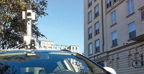
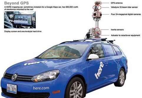
Whenever the head of the HERE map department, John Ristevski, drove his special car on the road, it always attracted a lot of attention. Everyone will stop at the same time and focus on the blue blue wagon. The top of the car is equipped with electronic equipment worth $80,000, and a world map is drawn on the side of the body.
This article refers to the address: http://
Ristevski's office is located near the University of California, and one of the two ladies once saw the car, one of them said it was a Google Maps car. This statement is inaccurate because Ristevski works for HERE, the map department of Finland's telecommunications company Nokia, not Google. Google has achieved good results in the field of autonomous vehicles. Ristevski has developed a state-of-the-art wagon that can help BMW and Daimler to compete with Google.
HERE installed the same electronic equipment for 200 wagons to build a three-dimensional map database, which ultimately optimizes the auto-driving car map data. In the past 18 months, map data collection vehicles have mapped millions of miles of road maps involving 30 countries on 6 continents. During this period, Mercedes-Benz and Continental have become HERE partners as they view Nokia Maps as a core element in the development of autonomous driving technology.
Ristevski believes that their products have a good competitive advantage compared to Google Maps. Although Google's related technology is indeed leading, HERE has the ability to make up for the gaps and shortcomings; in addition to the traditional competitors such as TomTom, HERE maps have been far ahead.
A map company played such an important role in the development of autonomous vehicles. It used to be difficult to see. After all, the map could not automatically detect that the vehicle had been transferred to the wrong lane, or that a child who was chasing the ball ran to the road. on. However, the three-dimensional map can convey to the system the information that the camera and sensor should obtain on the road segment. If the actual information is different, the system will analyze the abnormal situation more easily and then complete the most appropriate automatic control.
Google announced the development of self-driving cars in 2010, and the news shocked the entire automotive sector. So far, Google has collected 2,000 miles of 3D map data covering its corporate headquarters in Mountain View, California, and surrounding highways. However, this is only an attempt by Google Inc. They did not sell 3D maps.
In 2008, Nokia established the map department Navtep, renamed HERE in 2012, and has now become an important partner for automakers to develop autonomous vehicles. Last year Mercedes showed the results of autonomous driving technology, a S500 model autonomous control, completed a 62-mile trip from Mannheim to Pforzheim. The selection of such a route has important historical significance. As early as 1888, Bertha Benz completed a similar journey to prove the practicality of her husband Karl Benz inventing the car.
Collect data to make up for GPS shortage
HERE's map data collection vehicle travels on the road, collecting location information for each stop sign and street light to compensate for the inadequacies of existing navigation tools such as GPS satellite systems. Mercedes board member Thomas Weber said that GPS is a system developed for military purposes, but only the military can get very accurate data information.
Thanks to high-resolution digital cameras, laser positioning radar systems, GPS receivers, and equipment that monitors vehicle offset, tilt, and sway, HERE's map accuracy is 20 cm. As a designer of 3D maps, Ristevski is obsessed with this technical concept and calls it the “reality indexerâ€. Ristevski and Anthony Fassero co-founded Earthmine Maps in 2006, and later merged into Nokia in 2012, renamed HERE; the original purpose of the two-person three-dimensional map was to preserve historical sites (such as the Mesa Verde country in southern Colorado). Park), but early commercial activities were concentrated in Oakland, California. Auckland installed a pedestrian ramp on the city street, but did not mark it on the map. The government then found Earthmine and asked them to draw the map.
Now the road map can no longer be the same cross line as the spider web. HERE breaks the traditional concept. The lane includes space definitions such as curb lines and road signs. The three-dimensional map can also show the curvature and inclination of the road and prompt parking in front. Signs and traffic light information. Ogi Redzic, deputy director of the HERE Connected Vehicles Division, acknowledged that they plan to build a high-resolution 3D map database for US and European roads by 2018, and the company will showcase its existing 3D maps for the first time in the near future. It may be that by 2018, a fully self-driving car will not appear in the entire journey, but automakers have begun to develop semi-automated systems to achieve autonomous control under high-speed road conditions.
In Berkeley's office, Ristevski and his team are paying attention to the progress of the 3D map project in real time through an eight-inch wide display. They can see which map data collection vehicle is running at any time and know which areas have been collected. information. For example, in a windy and beautiful afternoon, collectors and drivers on the west coast of Australia and the United States are still working. The HERE Command Center shows that their vehicles are green, while drivers in Europe, Africa and East Asia have already left work. Vehicles in the Midwestern United States display blue, indicating that the driver is on the way to work; others are shown in cyan, indicating that the vehicle is not travelling as planned (the driver is sick and other factors).
Autopilot cars are of course the best if they can be used in 3D map collection projects. They don't need to stop and rest when they draw maps, they don't have to sleep, and they don't want to take sick leave. However, many unpredictable situations occur in the actual process. For example, insects must be removed in time to fly on the camera lens. In order to deal with such complicated conditions, the driver is still essential.
Sijee Fiber optic adaptors are part of passive components for FTTH ODN connectivity, Sijee Fiber optic adaptors are used to join two fiber optic patch cables together for realizing the transition between different interfaces and they are available for use with either single-mode or multimode Fiber Optic Patch Cord. Sijee Fiber optic adaptors can offer superior low loss performance with very high repeatability.
Sijee offers different types of fiber adaptors comply with ITU standard, main products including Fiber Mating Sleeve Adaptor, Fiber Hybrid Adaptor, Fiber Bare Fiber Adaptor , Fiber Mechanical Attenuator, Field Assembly Optical Connector (FAOC), Splice-On Connector, Semi-finished Fiber Connector, etc.
Optical Fiber Couplers,Optical Fiber Adapter,Fiber Optic Adapter, Fiber Optic Flange are available.
Features:
1. Compliant with: IEC, JIS, Telcordia
2. Convenience and ease of handling
3. Optical performance 100% factory tested
4. Flange or threaded mounting type
5. Ceramic/Zirconia or phosphorous bronze sleeves
6. Good changeability and repeatability
Applications:
1. Telecommunication networks
2. FTTX, FTTH
3. LAN, WAN, CATV networks
4. Fiber communications, Data communication networks and processing, Industrial, Mechanical and Military.
5. Active device termination


Fiber Adaptor
Optical Fiber Couplers,Optical Fiber Adapter,Fiber Optic Adapter,Fiber Optic Flange
Sijee Optical Communication Technology Co.,Ltd , https://www.sijee-optical.com